| Pontcysyllte Aqueduct and Canal * | |
|---|---|
UNESCO World Heritage Site | |
 The aqueduct | |
| Country | Wales |
| Type | Cultural |
| Criteria | i, ii, iv |
| Reference | 1303 |
| Region ** | Europe and North America |
| Inscription history | |
| Inscription | 2009 (33rd Session) |
| * Name as inscribed on World Heritage List ** Region as classified by UNESCO | |
| Pontcysyllte Aqueduct | |
|---|---|
| Carries | Llangollen Canal |
| Crosses | River Dee |
| Location | Froncysyllte |
| OS grid reference | |
| Maintained by | British Waterways |
| Designer | Thomas Telford |
| Trough construction | Cast iron |
| Pier construction | Brick |
| Number of spans | Eighteen |
| Piers in water | Four |
| Total length | 1,007 ft (307 m) |
| Width | 11 ft (3.4 m) |
| Height | 126 ft (38 m) |
| Boats can pass? | No |
| Towpath(s) | East side |
| Opening date | 1805 |
| Heritage status | Grade 1 |
| Coordinates | 52.97053°N 3.08783°WCoordinates: 52.97053°N 3.08783°W |

The Pontcysyllte Aqueduct (Welsh pronunciation: [ˌpɔntkəˈsəɬtɛ], full name in Welsh: Traphont Ddŵr Pontcysyllte) is a navigable aqueduct that carries the Llangollen Canal over the valley of the River Dee in Wrexham in north east Wales. Completed in 1805, it is the longest and highest aqueduct in Britain, a Grade I Listed Building[1] and a World Heritage Site.
When the bridge was built it linked the villages of Froncysyllte, at the southern end of the bridge in the Cysyllte township of Llangollen parish (from where it takes its name [2]), and Trevor, at the northern end of the bridge in the Trevor Isaf township of Llangollen parish. Both townships were later transferred to Wrexham County Borough following local government reorganisation.
The name is in the Welsh language and means "Cysyllte Bridge".[2] For most of its existence it was known as Pont y Cysyllte ("Bridge of Cysyllte"). Other translations such as "Bridge of the Junction" or "The Bridge that links" are modern, and incorrect, inventions, from the literal English translation of cysyllte being "junctions" or "links".The aqueduct, built by Thomas Telford and William Jessop, is 1,007 ft (307 m) long, 11 ft (3.4 m) wide and 5.25 ft (1.60 m) deep. It consists of a cast iron trough supported 126 ft (38 m) above the river on iron arched ribs carried on nineteen hollow masonry piers (pillars). Each span is 53 ft (16 m) wide. Despite considerable public scepticism, Telford was confident the construction method would work: he had previously built at least one cast iron trough aqueduct – the Longdon-on-Tern aqueduct on the Shrewsbury Canal, still visible in the middle of a field, though the canal was abandoned years ago. Part of what was originally called theEllesmere Canal, it was one of the first major feats of civil engineering undertaken by Telford, by then a leading civil engineer, supervised by Jessop, the more experienced canal engineer. The iron was supplied by William Hazledine from his foundries atShrewsbury and nearby Cefn Mawr. It was opened on 26 November 1805, having taken around ten years to design and build at a total cost of £47,000 (£2,930,000 as of 2011).[3][edit]
History
[edit]Structure
 |
The lime mortar used comprised lime, water and ox blood. The iron castings were produced at the nearby Plas Kynaston Foundry, Cefn Mawr, which was built for the purpose. The trough was made from flanged plates of cast iron, bolted together, with the joints bedded with Welsh flannel and a mixture of white lead and iron particles fromboring waste.[4] The plates are not rectangular but shaped as voussoirs, similar to those of a stone arch. There is no structural significance to this: it is a decorative feature only, following the lines of the stiffening plates (see below) in the castings beneath.[4] The supporting arches, four for each span, are in the form of cast iron ribs, each cast as three voussoirs with external arches cast with an un-pierced web to give greater strength at the cost of extra weight. Using cast iron in this way, in the same manner as the stone arch it supersedes, makes use of the material's strength in compression.[5] They also give an impression of greater solidity than would be the case were the webs pierced. This impression is enhanced by the arrangement of strips of thicker stiffening incorporated into the castings, arranged in the manner of joints between voussoirs. Cast plates are laid transversely to form the bed of the canal trough. The trough is not fastened to the arches, but lugs are cast into the plates to fit over the rib arches to prevent movement.[4] It was left for six months with water inside to check it was watertight.[citation needed] A feature of a canal aqueduct, in contrast with a road or railway viaduct, is that the vertical loading stresses are virtually constant. According to Archimedes' principle, the mass (weight) of a boat and its cargo on the bridge, pushes an equal mass of water off the bridge.
The towpath is mounted above the water in the trough. This arrangement allows the water displaced by the passage of a narrow boat to flow easily around it, enabling relatively free passage. Pedestrians and horses once used for towing, are protected from falling from the aqueduct by railings on the outside edge of the towpath, but the holes in the top flange of the other side of the trough, capable of mounting railings were never used. The trough sides rise only about 6 inches (15 cm) above the water level, less than the depth of freeboard of an empty narrow boat, so the helmsman of the boat has no visual protection from the impression of being at the edge of an abyss. The trough of the Cosgrove aqueduct has a similar structure, although it rests on trestles rather than iron arches. It is also less impressively high.
Every five years the ends of the aqueduct are closed and a plug in one of the highest spans is opened to drain the canal water into the River Dee below, for inspection and maintenance of the trough.[6][7]
[edit]World Heritage Site
The aqueduct and surrounding lands were submitted to the tentative list of properties being considered for UNESCO World Heritage Site status in 1999.[8] The aqueduct was suggested as a contender in 2005—its 200th anniversary year[9]—and it was formally announced in 2006 that a larger proposal, covering a section of the canal from the aqueduct to Horseshoe Falls would be the United Kingdom's 2008 nomination.[10][11]
The length of canal from Rhoswiel, Shropshire to the Horseshoe Falls including the main Pontcysyllte Aqueduct structure as well as the older Chirk Aqueduct, were visited by assessors from UNESCO during October 2008, to analyse and confirm the site management and authenticity. The aqueduct was inscribed by UNESCO on the World Heritage List on 27 June 2009, alongside previously inscribed sites such as the Taj Mahal, Great Wall of China and Stonehenge.[12]
In March 2010 it was reported that the site had attracted a thriving community of otters [13]
[edit]Gallery
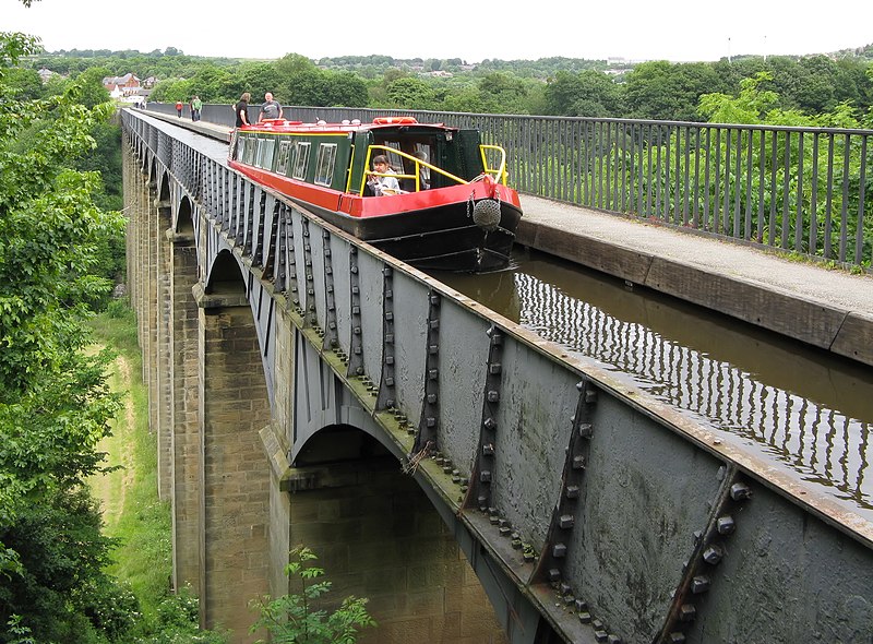 |
| A canal boat crossing the aqueduct. Note the shape of the iron plates, cast to give the impression of traditional stone voussoirs |
 |
| A view of the Dee Valley from the aqueduct |
 |
| From the floor of the valley |
No comments:
Post a Comment